By Rupert Wingfield-Hayes
09 September 2014
New islands are being made in the disputed South China Sea by the might of the Chinese state. But a group of marooned Filipinos on a rusting wreck is trying to stand in the way.
The boat pitches up and down and rolls from side to side in the heavy swell. The noise of the big diesel motor, just below the floor, is hammering at my head.
My nose is filled with the smell of dried fish and diesel fumes, my T-shirt glued to my chest with sweat. Proper sleep is impossible.
For more than 40 hours it has been like this. Our wooden fishing boat has tossed its way across the South China Sea. Most of the time we barely exceed walking pace. “Who would be a fisherman?” I wonder out loud.
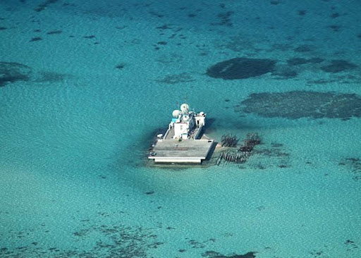
I stare out at the endless rolling waves. On the horizon the sky is dark and threatening. Then my eye is caught by something sticking up above the waves. It looks like an oil or gas-drilling platform. What on earth is it doing here?
As we get closer, to my right, I am sure I can now see something pale and sandy beside the platform. “That looks like land!” I say. It can’t be. I look at my GPS.
There is no land marked anywhere near here, only a submerged reef of the Spratly Island chain. But my eyes are not deceiving me. A few kilometres away I can now clearly see the outline of an island.
“What is this place called?” I ask our Filipino skipper.
“Gaven Reef,” he says.
“Get closer!” I shout over the din of the engine.
He turns the boat directly towards the islet. But the dark clouds are rolling in fast. Moments later we are enveloped. Water cascades off the fishing boat’s roof. The islet disappears.
“How long will the rain last?” I ask the skipper.
“Four or five hours, maybe longer,” he says.
My heart sinks. All this time, all this way, only to be beaten by the weather. But I know I have seen it, an island where there wasn’t one just a few weeks ago – even the skipper has never it seen before.
The captain turns the boat back to our old course – south, into the rain. We plough on. The waves are getting bigger. After four hours the rain begins to recede. Ahead I can see another island.
This one I am expecting. This place is called Johnson South Reef. On my GPS it again shows no land, just a submerged reef.
But I’ve seen aerial photographs of this place taken by the Philippine navy. They show the massive land reclamation work China has been doing here since January.
Millions of tonnes of rock and sand have been dredged up from the sea floor and pumped into the reef to form new land.
Along the new coastline I can see construction crews building a sea wall. There are cement-pumping trucks, cranes, large steel pipes, and the flash of welding torches.
On top of a white concrete blockhouse a soldier is standing looking back at us through binoculars.
I urge the skipper to get even closer, but a volley of flares erupts in the sky – it is a Chinese warning.
The appearance of these new islands has happened suddenly and is a dramatic new move in a longstanding territorial struggle in the South China Sea.
At the beginning of this year, the Chinese presence in the Spratly Islands consisted of a handful of outposts, a collection of concrete blockhouses perched atop coral atolls.
Now it is building substantial new islands on five different reefs.
We are the first Western journalists to have seen some of this construction with our own eyes and to have documented it on camera.
On one of these new islands, perhaps Johnson South Reef, China seems to be preparing to build an air base with a concrete runway long enough for fighter jets to take off and land.
Plans published on the website of the China State Shipbuilding Corporation are thought to show the proposed design.
China’s island building is aimed at addressing a serious deficit.
Other countries that claim large chunks of the South China Sea - Vietnam, the Philippines, Taiwan, Malaysia - all control real islands.
But China came very late to this party and missed out on all the good real estate.
Beijing only took control of Johnson South Reef in 1988 after a bloody battle with Vietnam that left 70 Vietnamese sailors dead. Hanoi has never forgiven Beijing.
Since then China has shied away from direct military confrontation.
But now Beijing has decided it is time to move, to assert its claim and to back it up by creating new facts on the ground - a string of island bases and an unsinkable aircraft carrier, right in the middle of the South China Sea.

There are many competing claims to territory in the South China Sea, but only China and Taiwan claim to own it all.
Beijing’s claim - not only to the Spratly Islands, but also the Scarborough Shoal and the Paracel Islands - is marked out on its own maps by the infamous “nine-dash line”, which encompasses a huge tongue-shaped expanse stretching right up to the coasts of the Philippines and Vietnam and even Borneo.
The Philippines and Vietnam also claim large areas of the South China Sea. Both say most of the Spratly Islands belong to them.
For decades China has done little to enforce its vague and sweeping claim. Now that is changing.
In 2012 the Communist Party reclassified the South China Sea as a “core national interest”, placing it alongside such sensitive issues as Taiwan and Tibet. It means China is prepared to fight to defend it.
This is confirmed by Prof Yan Xuetong of Beijing’s Tsinghua University - a pro-government academic well known for presenting the Communist Party’s view to the outside world.
China will fight, he says, if it feels its sovereignty in the South China Sea is under threat.
He blames Philippine President Benigno Aquino for “provoking Beijing”, by trying to bring America into the dispute.
“For him it is a personal problem,” Yan says.
“He rejects any bilateral negotiations. He says they are weak and we are strong. He will only negotiate together, with the Philippines and US as allies. He wants someone to stand at his side.”
Manila knows it has no hope of standing up to Beijing in a straight fight. The Philippine air force has no fighter jets. The navy has just two elderly frigates. So the Philippines has taken its case to the United Nations.
It wants a ruling based on the UN Convention on the Law of the Sea (UNCLOS), which typically gives coastal states an exclusive economic zone up to 200 nautical miles from their coastline.
An UNCLOS ruling would probably be good for the Philippines and bad for China. But Beijing has already made it clear it will not be bound by any ruling. And now it is building new islands.
This is all making the Philippines very unhappy.
Foreign Ministry spokesman Charles Jose says China’s claim is “expansive” and its island building “outrageous”. He says China is deliberately and unilaterally changing the status quo in the South China Sea as fast as it can before the UNCLOS ruling is handed down.
It is an oft-repeated statement that the coral atolls of the South China Sea sit atop potentially huge reserves of oil and gas. The struggle to control the Spratlys would certainly make more sense if it were true.
But a recent study by the US government suggests the main oil and gas reserves under the South China Sea do not lie anywhere near the Spratly Islands.
For China the struggle over the South China Sea is less about resources, though, than it is about sovereignty and strategic space. Nor is this just a quarrel with the Philippines and other countries bordering the sea.
Instead it is about China’s real strategic rival - the United States. The US government does not acknowledge China’s claim, and the US Pacific fleet continues to sail regularly through the South China Sea. But the Chinese navy is beginning to grow more assertive.
In December 2013 China sailed its brand new aircraft carrier, the Liaoning, into the South China Sea for the first time. Shadowing it, at about 30 nautical miles, came the US Navy cruiser USS Cowpens.
A Chinese amphibious assault ship approached and ordered it to leave the area. The commander of the Cowpens refused, saying he was sailing in “international waters”.
At that point the US Navy says the Chinese ship suddenly swung across the Cowpens’ bow, just 500m ahead, forcing the US warship to take evasive action.
In 1823, US President James Monroe outlined what was later to become known as the “Monroe Doctrine”.
It identified the Western hemisphere as America’s backyard, and nowhere more so than the Caribbean Sea. Old European colonial powers were told to keep out.
Today China is doing something very similar in the East and South China seas.
Everything inside the so-called “first island chain” - which stretches north in a curving line from the coast of Borneo, past Taiwan to southern Japan - is in Beijing’s opinion, China’s backyard. Beijing’s ambition is to dominate this sea-space and, ultimately, to deny access to the only other naval power in the world that can prevent China from doing so.

The first map showing the nine-dash line had 11 dashes - Chinese premier Zhou Enlai asked for two to be removed
Stepping off the fishing boat after two days and nights at sea is a blessed relief.
I wade across a reef through crystal clear waters and on to a white sandy beach. As I look back out to sea, our little fishing boat is rocking at anchor.
I am struck by just how remote this place is.
Pagasa is a tiny speck of land halfway between Palawan, the westernmost province of the Philippines, and the coast of Vietnam. The nearest Philippine port is 250 nautical miles away.
The island doesn’t even have a proper jetty. They started building one 10 years ago, but the ship bringing building supplies got stuck on the reef.
It’s still sitting there today, rotting away.
An eccentric Filipino businessman called Tomas Cloma first occupied Pagasa in 1956.
He declared it part of a new nation he named “Freedomland”.
But 15 years later Cloma was arrested and forced to hand over his “country” by Philippine dictator Ferdinand Marcos.
He was reportedly paid just one peso by a (not very) grateful nation.
Marcos set about converting the tiny island in to a military stronghold. An airstrip was constructed. Concrete bunkers were built along the shoreline and anti-aircraft gun emplacements.
Today the concrete bunkers are sliding in to the sea; the anti-aircraft guns are rusted solid.
Only the airstrip remains usable.

There are still 30 Philippine marines based on Pagasa.
When I go to meet their commander, at 10am, I am told he is asleep. By late afternoon the major has woken up, although he’s still a little grumpy.
“No-one informed me that you would be visiting Pagasa,” he says. “I had no communication about this!”
I assure the major we did inform navy headquarters about our trip. He looks nonplussed.
But soon his annoyance is forgotten and I am invited to a meal of fried fish, vegetables, rice and, luxury of luxuries, cold Coca-Cola.
I ask the major what weapons his men have. “It’s classified information,” he says. I look around. It can’t be more than a few automatic rifles.
The marines won’t be stopping the People’s Liberation Army, if it ever decides to clear them out.
Pagasa’s most important asset lies at the far end of the island - a ramshackle village with about 30 families.
Manila claims more than 200 people live here, but I found only about 100. The civilians started coming in the late 1970s and gradually they have built a little colony here – though not out of patriotic zeal.
“We get a free house, and free food. The government gives me a job, and there is a school for our children,” says Melody, who lives here with her husband and three children.
“Back on the mainland everything is so expensive compared to here.” In a country where nearly a quarter of the population lives below the poverty line I can see her point.
Our host on Pagasa is Mary Joy. She came here two years ago to start a fishing business. It failed. So she took a job as the island’s administrator.
Mary Joy has big plans. The community hall needs to be finished. A proper harbour must be built. She even talks of a resort hotel on the pristine north beach. If only there were more money.
“The Chinese have so much money,” she says. “We have so little. But it is really important for us to stay here. If we don’t I think the Chinese will come in here.”
The South China Sea is dotted with these strange little military outposts and civilian colonies. It’s often hard to decipher which is which and who controls what.
Pagasa used to be called Thitu Island. In Chinese it is Zhong Ye Dao, and in Vietnamese Dao Thi Tu.
Johnson South Reef is also known variously as Chi Gua, Yongshu, Gac Ma and Mabini reef.
And so it goes for the dozens of other islets, reefs and sand bars.
The Philippines has nine permanently occupied outposts. Vietnam has eight, Malaysia also has a handful off the coast of Borneo - and China, so far, has seven.
Even stranger, the biggest island in the Spratlys, Taiping Island, is controlled by Taiwan. There is a large military base on it and a concrete airstrip.
Like the Philippines, Vietnam is settling civilians on several of the islets it controls. Civilian colonies certainly make military confrontation more difficult and less appetising.
Shooting soldiers, as China did at Johnson South in 1988, is one thing. Shooting women and children is quite another.
Whether these heavily subsidised micro-colonies really strengthen legal claims to places like Pagasa has yet to be tested. Clearly, Manila and Hanoi believe they do.

Sixteen hours after leaving Pagasa, just before dawn, our little fishing boat is approaching Ayungin Shoal, also known as Second Thomas Shoal.
The engine is screaming as the skipper pushes it to full power. Three crewmen are standing on the wheelhouse giving directions to the captain below.
Straight ahead a white line of waves crashes across a just-submerged reef. Somehow we must cross it without getting stuck.
A few hundred metres away the dark outline of a ship is silhouetted against the pale dawn sky.
It is the Sierra Madre, a Philippine ghost ship stranded on the reef.
To the south, I can see the lights of two Chinese coastguard cutters steaming towards us. But they are too late.
In a moment we are over the reef, and the water is now too shallow for the large Chinese ships to reach us.
I had seen photographs of the Sierra Madre before I set out. But the reality is still a shock.
The ship’s sides are peppered with massive holes. Waves slosh through them right into the ship’s hold.

On the deck a group of smiling Philippine marines is hailing me to come aboard.
“Hello! Welcome Mr Rupert!” they shout.
This time it seems someone has radioed ahead. A terrifying homemade rope ladder is hanging over the ship’s side. Gingerly, I haul myself up.
From the deck, the ship’s condition looks possibly even worse. In many places there is no deck, just rusting holes covered with old doors and bits of plastic.
“Be careful,” the marines caution, “don’t walk there it’s dangerous!”
As I climb a stairway a piece of rotten railing comes off in my hand.
“Sorry,” I blurt out. “I appear to have broken off a bit of your ship.”
Around the Sierra Madre the sea sparkles aquamarine. Schools of reef fish flit back and forth.
The absurdity of the Sierra Madre is almost comic. Or perhaps it’s tragic.
Even the 11 Filipino marines stranded on board seem embarrassed by their circumstances.
There is little of the normal marine bravado, just a quiet acceptance of their fate.
“It is hard for my men,” the young lieutenant in command of the group tells me. “We are far from home, there is sometimes little to eat, so it puts a great strain on the men.”
A few hundred metres away we can see the shiny new Chinese coastguard cutters roaming up and down.
This is not a contest of equals.
For the past year the Chinese ships have been blockading the Sierra Madre, preventing resupply ships, with food, water and building materials, from getting through.
Had we approached from the south-west they would have cut us off. We only made it by arriving from the opposite direction, under cover of darkness.
The Philippine navy now drops supplies to the stranded ship by parachute, once a month.
But the marines say much of the time they live off fish they catch on the reef.

Ayungin Reef is (according to my GPS) 120 nautical miles from the coast of the Philippines.
That puts it well within the Philippines’ claimed 200-nautical-mile “exclusive economic zone”. It is more than 800 nautical miles from the Chinese coast.
An yet Beijing claims that this submerged reef is an integral part of Chinese territory.
China is just at the start of its rise as a naval power. The speed of change is breathtaking.
Right now China is building new naval ships and submarines faster than any other country in the world, including the United States.
A second aircraft carrier is on the way. The US Navy is still much bigger and more powerful. But the gap is closing faster than anyone expected.
What’s going on in the South China Sea is an expression of China’s intent. Beijing’s ambition is to dominate the sea-space within the “first island chain”.
In the longer term it wants to move further, beyond the Philippines, and southern Japan - to the “second island chain”... to Palau, Guam and the Northern Mariana Islands.
This will be a seismic shift in the balance of power in the Western Pacific. For the past 70 years US power has been unassailable in this region.
Now, for the first time, a new power is emerging with the will and the means to challenge America’s military dominance. It is unlikely to be a smooth ride.

Credits Author
Rupert Wingfield-Hayes Photography and video
Jiro Akiba Video editor
Futa Nagao Field producer
Chika Nakayama Fixer
Jinky Jorgio Additional images/video
Armed Forces of the Philippines
Online production/editing
Paul Kerley
Stephen Mulvey Features editor
Giles Wilson
Web development
No comments:
Post a Comment